

By Michelle Pelletier Marshall, Women in Agribusiness Media (This interview is reprinted from our sister publication, Women in Agribusiness Today.)
A geographer at heart with more than 15 years in academia as a research assistant and professor, Dr. Alyssa Whitcraft was the perfect candidate to establish NASA Acres (National Aeronautics and Space Administration), a new U.S.-focused agriculture and food security program established just last year. Her vision and focus on the importance of spatial thinking in global problem-solving through the lens of satellite-based remote sensing were key to developing this program, which helps understand and monitor agricultural outcomes, from field to global scales.
Dr. Whitcraft is globally recognized as a thought leader in advancing the use of satellites for agriculture and promoting science for the public good. She is celebrated for her contributions as the former deputy director of NASA Harvest, NASA’s globally-focused food security consortium, which preceded and laid the foundation for NASA Acres’ domestic work.
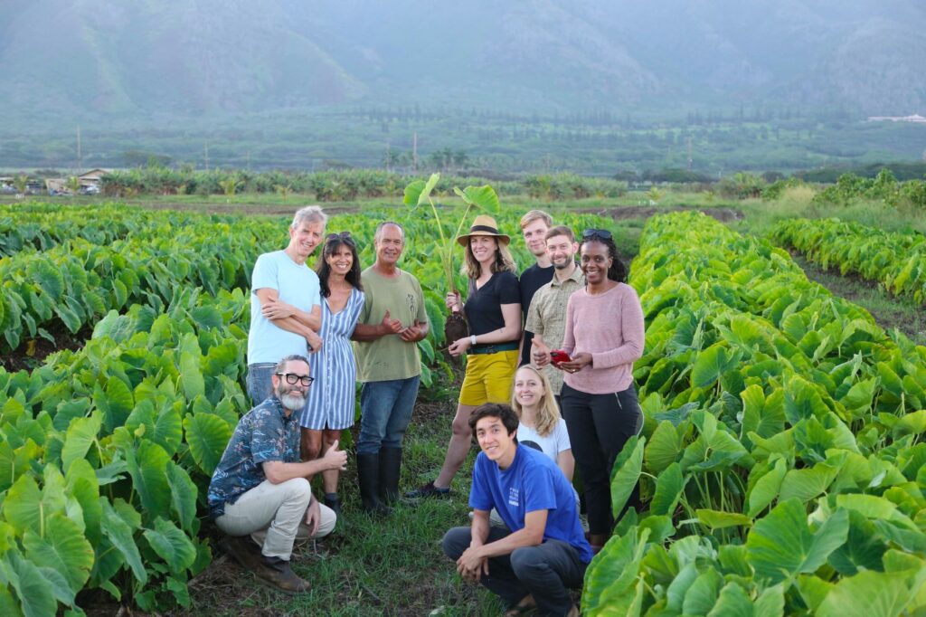
Dr. Whitcraft (center, with hat) during a trip to Maui with the NASA Acres team from Arizona State University. Image courtesy of NASA Acres.
Recognizing the need for a neutral, authoritative body to convene multi-disciplinary, trans-sectoral actors to improve satellite-based agricultural assessment of “sustainable,” “regenerative,” and “climate-smart” management practices, Dr. Whitcraft founded the Harvest Initiative on Sustainable and Regenerative Agriculture (SARA). This initiative brings together private and public sectors in a nonprofit pre-competitive forum to strengthen the evidence base for SARA practices at scale. In both of her executive roles, Dr. Whitcraft is tasked with uniting top scientists from physical, social, and economic sciences with agriculture stakeholders towards a shared mission to bring NASA data, science, and tools “down to Earth” for the benefit of U.S. agriculture.
Attendees to this year’s Women in Agribusiness Summit are set to learn more as Dr. Whitcraft kicks off this 13th annual conference in Denver on Tuesday, September 24 as keynote speaker. She will present the case for the use of satellite data for monitoring, mapping, and improving agricultural outcomes near and far, and illustrate the importance of these outcomes in building trusting and mutually beneficial relationships with the producers whose on-farm data is foundational to this work.
WIA Today caught up with Dr. Whitcraft last week to get more details.
1). What sparked your interest in remote sensing and satellite technologies?
I was pre-med in college, and during my sophomore year I took a geography course about “People and Earth’s Ecosystems” and I loved it. I bonded with the professor and ended up doing internships with him for the rest of college. I had never heard of remote sensing, but he covered a lot of remote sensing of the tropics, principally tropical dry forests. It was around the same time that Google Earth became a thing, so the world was opening up in terms of satellite data. With that, I ended up switching majors. As I moved through grad school and getting my Ph.D., I had my eye on agriculture because it was always an interest having grown up helping with my family’s winery in Santa Barbara, California. I saw remote sensing as a very viable pathway for me to contribute to agricultural well-being in a way that also checked the box for me intellectually.
I ended up joining a research group at the University of Maryland led by Chris Justine – one of the foundational giants in the satellite remote sensing world – and Inbal Becker-Reshef – who revolutionized the use of satellite data for agriculture and later became the director of NASA Harvest. Chris empowered me to work with the space agencies by providing guidance on what was the best way to configure their satellites to gather imagery to support agriculture.
To this day, I’m still the agriculture lead for the consortium of the world’s space agencies through the Committee on Earth Observation Satellites. I represent those who use the satellite data for food security and agriculture – applications like early warning of crop shortages and failures, analyzing current season conditions for markets and trade analyses, developing longer-term analyses of agricultural change, and more. It is only now, though, that the space agencies are really listening to the needs for satellite imagery stemming from precision agricultural applications.
2). NASA is known for dealing with space travel and initiatives… how does agriculture fit into this picture?
What a lot of people don’t realize is that NASA has an entire Earth Science Division and has been observing and collecting data on agriculture for 50 years. NASA launched the first Earth observing satellite in 1972, and one of its earliest applications was to develop global crop production outlooks. So the longest application of satellite data is in agriculture, even though fewer than one in three farmers know that NASA works in agriculture at all. So, we still have a lot of mileage to cover. We touch agriculture in other ways, too – we work collaboratively with the USDA’s National Agricultural Statistics Service Information (NASS) and other parts of the USDA, and with the National Oceanic and Atmospheric Administration (NOAH) for weather forecasting, for example.
3). What is the difference between NASA Harvest and NASA Acres?
While NASA has been collecting satellite data and applying it to agriculture for years, there wasn’t a formal program on agriculture that pulled it all together. So, in 2017 NASA Harvest was established through a public solicitation to build a consortium that would create NASA’s program in agriculture. Inbal and Chris, who I mentioned before, and I wrote the proposal together that was selected and eventually became NASA Harvest, with Inbal as executive director, Chris as chief scientist, and me as deputy director and program manager. NASA Harvest’s portfolio is heavily weighted in international projects just by virtue of the heritage of the more mature applications of satellite data for agriculture, which involves large-scale applications in national statistics, global trade, and food security. It has a big portfolio in Africa, and since 2022 has done a lot of rapid response work to emerging agricultural crises that result from conflict.
After five years, NASA was very pleased with NASA Harvest’s international impact, and continued it for another five years. Then they sought out a more U.S.-focused effort and put out another solicitation for that in 2022. This time, I led the proposal team and it was selected and ultimately called NASA Acres with me serving as executive director. NASA Acres is more focused on farmers with an eye toward building resilience and strengthening the future of U.S. agriculture. A key interest of mine that I see as crucial to securing U.S. agriculture long-term is increasing our understanding of different management treatments towards different outcomes.
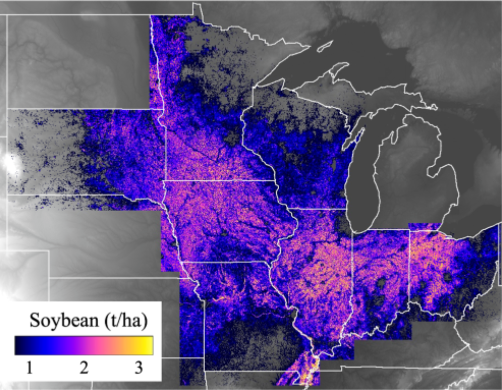
Map of sub-field level soybean yield for 2022 across the U.S. Midwest. Image courtesy of NASA Acres. Map production by Drs. Yuchi Ma and David Lobell of Stanford University.
4). How does the Harvest Sustainable and Regenerative Agriculture Initiative (SARA) fit into this?
About two years after NASA Harvest was started, it became clear that we had a gap in the program as we had a lot of private companies coming to us and saying, “Can you verify my product or tool or service?” Or, “How can you help us with our supply chain or certifications?”, whether it was for carbon, or sustainability. We felt strongly that we needed to address this gap, and we needed to do it in such a way that it didn’t benefit any particular company, and that we remained neutral in our standing and recommendations. Scientific rigor is our brand.
With that, in 2020 we launched a 501(c)3 organization called the Harvest Sustainable and Regenerative Agriculture (SARA) Initiative. It’s global in scope, although it has a heavy focus in the U.S. just by virtue of who’s involved right now. But we do run on donations. And when we get donations, we can’t be directed to do any type of research, it must be in line with our mission and our mandate. Also, the findings do not exclusively benefit the donors, because they are available to the public – responding to the need we heard from people all across the agriculture value chain.
5). How important is satellite-based data in helping to shape the future of agriculture?
Well to begin with, there is more than 50 years of data available. It’s worth googling the NASA Scientific Visualization Studio to search their different visualizations and animations. You can see long-term studies of deforestation and conversion to agriculture in Brazil, for example, and see images over time and predictive models.
Just how much value is this data going to bring to the precision ag space? Historically, it has fallen short – in my humble opinion. I think digital agriculture and agtech in general have struggled to get farmer buy-in. It’s really important to not overpromise what a technology can d0 – which is somewhere I always start when talking to new people: “satellite data are amazing, but they aren’t magic and they aren’t going to solve world hunger.”
But we do offer the best of what satellite data and models can do, and we bring together the private companies and the public sector – scientists and modelers – to improve methods collectively so that we can better understand and improve agriculture. Whether that be helping a farmer decide to adopt a new practice like reduced tillage or cover cropping – the value of our data comes from covering large areas over long periods of time where we can see where farmers have already adopted these practices and then can help predict how it might work in new areas.
But I believe, and many others do too, that if somebody’s going to make a change on a farm, it must make sense. My new favorite phrase, which came from a sorghum grower, is, “if it don’t make dollars, it don’t make sense”. So we have to figure out how to balance the multiple needs of each little piece of agricultural land, and think about the fact that if a farmer is going to make a practice change, he or she needs very strong evidence that it’s going to be worth it, that it’s not that going to endanger the bottom line.
6). We are very excited to welcome you as our keynote speaker for the WIA Summit this September in Denver. What can our attendees expect to learn?
At the very highest level, they will discover how data plays an important role in agriculture and the integrated measurement system. I’ll talk broadly about data and agriculture and satellites and NASA’s impact in this endeavor, and I’ll demonstrate some of our early findings and discuss the tools and products that we’ve developed. There’s plenty to talk about with NASA, such as how our analysis can assist with defining and then implementing sustainable farming, unpack drivers of variability in yields, and help farmers protect their land and legacy. The in-depth data we have within our reach is key to driving positive change and innovation in the ag sector, and we are excited to show how this can happen.
ABOUT ALYSSA WHITCRAFT
Dr. Alyssa Whitcraft is a geographer who focuses on satellite remote sensing of agriculture. As the founding executive director of NASA Acres and the co-founding deputy director of NASA Harvest – the U.S. and international NASA consortia on food security and agriculture – she has been a key factor in the acceleration of innovation in the growing space-for-agriculture sector.
Dr. Whitcraft also is the founding executive director of the Harvest Sustainable and Regenerative Agriculture (SARA) Initiative, a 501(c)3 dedicated to using the lenses of satellite data and models to build a globally consistent and site-relevant evidence base for SARA management.
Since 2012, she has served as a program scientist for the G20 Global Agriculture Monitoring (GEOGLAM) Program, where she works with the world’s space agencies to ensure their satellite missions address agricultural needs.